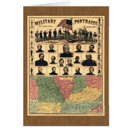
Civil War Border Military Portraits 1861, Restored
Title: Military portraits, map of the seat of war, uniforms, arms, &c. Published: 1861 LC Civil War Maps (2nd ed.) N.Y., New York H. H. Lloyd & Co. Map of western border states -- Missouri, Tennessee, and parts of Nebraska, Kansas, Indian Territory, Arkansas, Illinois, Indiana, Ohio, Kentucky, Virginia, North Carolina, and South Carolina, showing cities and towns, rivers, and railroads. Important sites marked in red. Portraits of Generals Wool, Dix, Scott, Fremont, Lyon, McClellan, Banks, Blenker, Butler, McDowell, Rosecrans (Rosencranz), Sprague, Burnside, and Sigel, Colonel Corcoran, and Commodore Stringham. Digitally restored by VintageSketch to reduce creases and smudges; colors enhanced.
8 resultados
Cartão Retratos Militares da Fronteira da Guerra Civil de
Preço de venda 4,74 €. Preço original 5,26 €.


Outras Coleções que você pode gostar por VintageSketch
Itens visualizados recentemente